Article
14 minute read 14 July 2021

The rise of spatial thinking

What role does location play in your business—or your next business?

Matt Gentile

Matt Gentile

United States

Jerry Johnston

Jerry Johnston

United States

Jonathan Camhi

Jonathan Camhi

United States

For many organizations, location is more important than ever for key decision-making. And multiple technology trends are making the insights of geospatial analytics increasingly accessible and valuable.

Location-aware devices and services have exposed billions around the world to how technology can support “spatial thinking.” Whether searching on Google, navigating to an address on smartphones, ordering a shared ride, or tracking a food delivery, many people use spatial-aware technology routinely. Products such as Tile’s beacon trackers or Apple’s recently released AirTag accessories suggest a future in which people will know the location of anything they want at any time.1

And organizations are moving to analyze location data for a wide range of critical insights, with major implications. Geospatial analytics can be an important source of innovation, helping solve problems across talent, operations, marketing, risk, and beyond. It may even be instrumental in organizationwide transformation, changing how everyday business and operations are conducted, though minding ethical boundaries will be crucial in taking advantage of this technology’s potential.

Signals

  • Location-sensing technologies are dropping in price. The cost of location-enabled chips for cellular connectivity, for example, is expected to decline by 70% from 2017 to 2023.2
  • Launches of new vendor hardware and software products that support geospatial analytics increased more than 30% in 2020 compared to 2019.3
  • Machine learning (ML) and deep learning with spatial data are enabling use cases such as managing disease outbreaks or natural disasters.4
  • Once dominated by public-sector applications, a recent analysis identified dozens of geospatial analytics applications in commercial sectors including financial services and insurance; consumer; and energy, resources, and industrials.5
  • Ethical guidelines are emerging for handling privacy concerns with location-tracking technology.6

Spatial thinking enters the mainstream

Data analytics aims to provide answers to critical questions about who, what, when, and why: Who are my best customers and who is most likely to churn? What are my best-selling products? When will this machine need service in the future? Why did my revenue change from last quarter? 

The power of geospatial analytics lies in answering where questions: Where are our customers interacting with us? Where are our assets and staff deployed? Where do we have exposure to supply chain or regulatory risk? Beyond telling us where things are, analyzing data through the lens of location can help answer where they should be: Where should we build new store or office locations? Where should we direct more marketing spend? Where should we acquire new talent based on local market conditions? Lowe’s, for instance, optimized new store locations by identifying trade areas with a favorable demographic profile.7

Three factors appear to be driving this trend: The volume and diversity of location data is exploding, the cost of acquiring and analyzing it is declining, and clever applications that create value for businesses and their customers are emerging. A leading Indian bank, for example, cut the traditional credit decisioning process for farmers to just a few days—compared to the industry average of 15 days or more—by analyzing satellite imagery instead of manually inspecting farmland.8 A more novel example: using real-time tracking of drone flights to measure flight risk and lower premiums for insuring enterprise drone fleets.9

Spatial thinking increasingly plays a pivotal role in tackling big, complex challenges such as addressing climate change, managing COVID-19 risks, and supporting a hybrid workforce. It can help answer questions such as: Where should we deploy resources to mitigate climate risk? Where is there greater risk of exposure to COVID-19 for staff or customers? Where should we consolidate our office footprint as we shift to a hybrid workforce model?

The volume and diversity of location data is exploding, the cost of acquiring and analyzing it is declining, and clever applications that create value for businesses and their customers are emerging.

Geospatial analytics: A powerful tool for spatial thinking

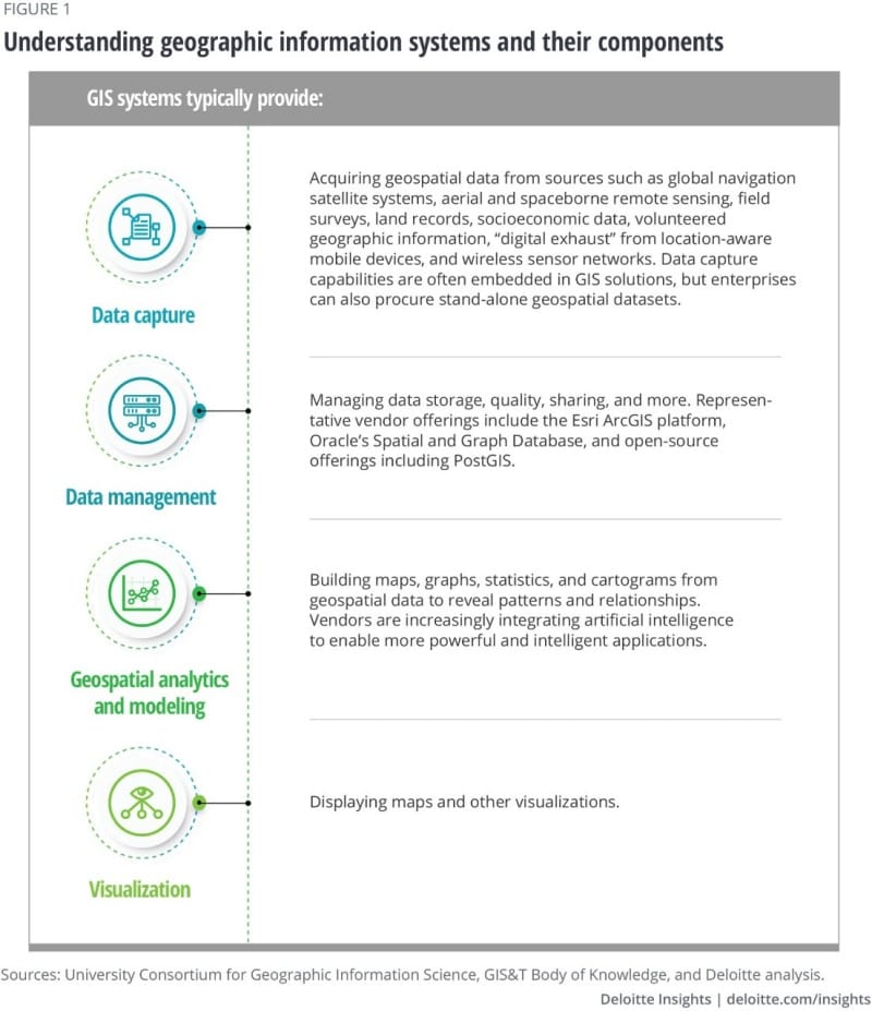
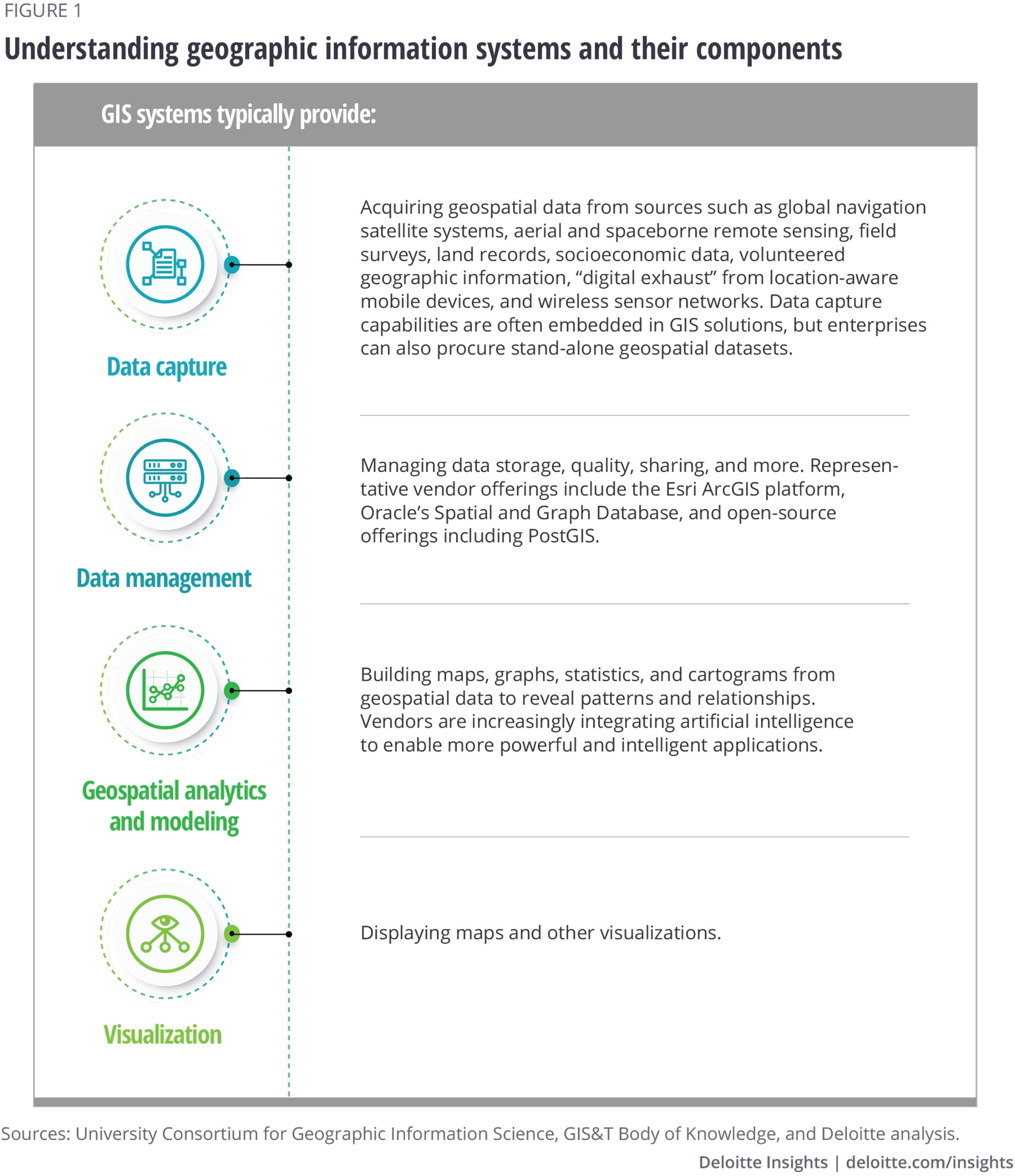
Geospatial analytics—the practice of analyzing data with a spatial dimension—typically requires multiple steps: collecting geospatial data from varied sources such as surveys and sensors, turning data into multiple layers of spatial representations, and analyzing it to find useful patterns to inform operational or strategic decisions.10 Performing each step may call for specialized skills and assets such as remote sensing and image processing tools for data collection and classification, specialized geospatial analysis skills (including cartography) to analyze spatial information in context and guide decisions, and specific programming languages to generate insights.11 Leading adopters generally use geographic information systems (GIS)—specialized software systems purpose-made for storing, managing, analyzing, and visualizing geospatial data; see figure 1 for a list of typical GIS components.12 The global GIS market is expected to reach US$13.6 billion in 2027, up from US$6.4 billion last year.13

Many organizations haven’t yet experimented with geospatial analytics, but adoption is growing fast. In the past, government organizations were typically the main producers of geospatial data; they were able to afford the high costs of acquiring it—from sources such as aerial and satellite imagery or manually collected survey data—along with the requisite highly specialized talent skilled in drawing insights from it. By next year, though, 36% of large and mid-sized organizations are expected to have deployed location intelligence software, up from 10% in 2019.14 And private-sector efforts to acquire geospatial data are proliferating.

New sources and tech expand geospatial data supply, solutions, and tools

The geospatial technology industry has experienced rapid growth and change since hyperscalers such as Google, Microsoft, and Apple entered the market. Beginning with the release of consumer and professional offerings in the early 2000s, awareness of the power of geospatial data and analytics has continued to expand around the world.15 At the same time, the cost of sensors and devices that collect geospatial data is falling rapidly—Bluetooth tags with integrated power-harvesting are expected to drop in price by two-thirds—with corresponding proliferation and ever more data. By 2025, projections suggest 40% of connected IoT devices will be capable of sharing their location, up from 10% in 2020.16 Even the sky-high costs of launching a satellite have fallen sharply over the past decade on a per-kilogram basis,17 meaning more data-collecting satellite launches over the next few years.18 The expansion of 5G networks, too, will aid collection of greater volumes of geospatial data, with faster speeds and improved accuracy; a defense organization is now developing a prototype of a 5G-connected warehouse that will make it possible to continuously and precisely track the location of its assets and inventory.19

Artificial intelligence (AI) and machine learning (ML) has supercharged organizations’ ability to analyze vast quantities of geospatial data. AI and many of its subdomains, including ML and computer vision, automate information extraction to more quickly deliver real-time geospatial insights, such as helping to safely deploy firefighters during rescue operations20 or enabling autonomous or remote navigation for drones or vehicles.

Many new tools and solutions that make use of geospatial analytics are coming to market, especially industry-specific solutions that embed geospatial capabilities. And venture capital (VC) is pouring into this space, supporting the growth in new geospatial solutions, tools, and data sources. US-based startups offering geospatial capabilities raised US$2.5 billion in VC funding in 2020, about 25% more than in 2019. That trend continued this year, as VC investment topped US$1.8 billion by early May.21

Meanwhile, market-leading GIS and geospatial technology vendors (including Esri, Hexagon, and Descartes Labs) are modernizing their tools by launching their software offerings on the cloud for flexible storage and processing power to handle growing data volumes.22 And major enterprise software vendors are adding geospatial functionality to their core products. Cloud hyperscalers have launched geospatial data and analytics offerings, including services for embedding maps, geofencing, and other location-based features into clients’ web and mobile applications.23 SAP, Salesforce, Oracle, and others are integrating more geospatial capabilities through new partnerships,24 investments,25 and offerings.26 This will allow many more organizations to begin experimenting with geospatial analytics, including building custom geospatial applications on vendors’ platforms.

Growing demand: Geospatial analytics finds new ground

With the volume and variety of geospatial data growing, and new tools making it easier to work with, new applications have emerged. Location data aided COVID-19 contact-tracing programs all over the world27 as well as social distancing programs in organizations’ facilities.28 A California-based interior-design firm is using location data to support its shift to a hybrid workforce model: A mobile app allows employees to view real-time and projected office occupancy and book open desks, with indoor wayfinding to help them navigate office floors, facilitating better space planning and social distancing adherence.29 (See figure 2 for examples of geospatial use cases across industries.)

Proliferating IoT devices are boosting opportunities in emerging areas such as indoor mapping and tracking and location-based products. A California hospital shrank operating-room turnaround times, improved patient satisfaction, and saved US$1 million in annual costs with real-time patient tracking with RFID.30 Wearable technology can power products that remotely monitor the precise location and vital signs of first responders to increase their safety on the job.31

Geospatial analysis of satellite imagery and other data sources can be vital to mitigating climate risk. A joint US-EU program is using satellites to more accurately measure the rate that sea levels are rising around the globe, while also capturing atmospheric data to augment climate change models and weather forecasts.32

Such emerging applications are expected to fuel further demand for geospatial analytics. In the United States, the Biden administration has proposed investing US$50 billion in infrastructure resilience to mitigate climate risk.33 Geospatial analytics can help direct such investments toward high-risk areas to maximize their impact. Another example: California-based startup Pachama recently raised US$15 million to verify forest restoration projects for climate offsets with satellite imagery. It counts Microsoft, SoftBank, and Shopify among its enterprise customers.34

With the technology becoming more accessible, organizations are ramping up use of established geospatial analytics applications. Examples include Novartis analyzing local talent pools for office site selection,35 parcel delivery provider SEUR optimizing its supply chain network,36 the Rwandan government working to improve land management practices,37 and an American power utility reducing costs in managing risk from vegetation along its powerlines.38

Implications for strategists

As new geospatial data sources and use cases emerge, organizations should respond by reviewing strategy and operations through the lens of spatial thinking. Using the following approach, leaders should look for opportunities where geospatial insights can provide a competitive edge or produce significant operational advantages:

  • Identify the “where” questions in your organization that can be answered with geospatial analytics. Spatial thinking can help leaders understand where they can optimize existing operations and business offerings. For some organizations, geospatial may become a catalyst for broad transformations, driving large-scale improvements in mission-critical processes and strategic decisioning. Government agencies at all levels, for instance, are using geospatial analytics to transform how they deliver services, aiming to ensure that programs distribute resources in an equitable manner and reach vulnerable communities. This includes current efforts to assess the equity of COVID-19 vaccine distribution.39
  • Develop use cases for unlocking value from the applications of spatial thinking. Geospatial data and analytics can also enhance new data-driven offerings, unlocking revenue opportunities. Airbus, for instance, entered the agricultural technology business by analyzing satellite imagery for farmland monitoring and benchmarking.40 Sumitomo Mitsui Banking Corporation piloted a geospatial solution for finance, retail, and logistics clients to monitor risks from macro socioeconomic factors, such as global supply chain movements or commodity trends.41
  • Build your geospatial leadership team. Depending how deeply an organization ends up integrating geospatial analytics into everyday operations, leaders might consider establishing a geospatial center of excellence or a geospatial information officer role to develop standardized processes, evaluate vendors and technologies, and work with businesses in cross-functional teams to identify applications. In some organizations, this capacity would be housed under the CIO as a multidisciplinary team combining traditional IT skills (cybersecurity, data privacy, infrastructure management) with specialized science skills (geography, engineering, cartography, computer science) critical for understanding and unlocking insights from geospatial data. In the public sector, geospatial practitioners are increasingly becoming the foundation for data-driven organizations and reporting to or working closely with chief data officers.42
  • Keep ethics and appropriate use of geospatial data and technology front of mind. While organizations look to generate new value from geospatial data, they must remain mindful of privacy concerns, since rigorously managing data access rights and privacy is crucial to ensuring customer trust with emerging technologies.43 That very much includes geospatial data and analytics: Any geospatial data attributable to a specific individual should be handled according to the same standards as other personal data.44 Consortiums and research groups are starting to publish geospatial-specific ethical use guidelines on addressing bias in data collection, minimizing collection of unnecessary data, and gaining informed consent when collecting data from individuals.45

Where is the future

By now, many leaders recognize the role of analytics and data mastery in unlocking business value and achieving their organizations' digital ambitions. Increasingly, this means mastering the use of geospatial analytics and spatial thinking. For some organizations, this could be transformative—even becoming a launching pad for entirely new businesses.

The internet has freed people from being tied to a specific location. Education, work, and entertainment are available anywhere there is a network connection. And yet location matters now more than ever. Leaders’ best thinking should include spatial thinking.

  1. Tile, “About Tile ,” accessed June 5, 2021; Apple, “Apple introduces AirTag ,” April 20, 2021. This article is an independent publication and has not been authorized, sponsored, or otherwise approved by Apple Inc.View in Article
  2. See Nick Jones, “Unlock the innovation potential of future location-sensing technologies ,” Gartner, March 31, 2020; Jones, “Architecting for location ,” Gartner, December 15, 2020. In 2017, a cell model and GPS chip cost US$20; in 2023, a 5G NB-IoT chip might cost under US$6 and have 75 meters of precision.View in Article
  3. Deloitte analysis based on Factiva. Included offerings involve capturing, analyzing, visualizing, and/or producing insights using location or geospatial data.View in Article
  4. Bill Finnerty, “Use geospatial and location intelligence to optimize government collaboration and decision making ,” Gartner, October 9, 2019.View in Article
  5. Deloitte analysis of 50 use cases.View in Article
  6. American Geographical Society, “The American Geographical Society’s EthicalGEO Initiative launches Locus Charter in partnership with Benchmark Initiative ,” March 24, 2021.View in Article
  7. Orbital Insight, “How big data identified where the next Lowe’s should go ,” November 5, 2019.View in Article
  8. Reuters , “India’s ICICI Bank uses space images for farm loans to cut costs ,” August 25, 2020.View in Article
  9. Geospatial World , “Flock launches ‘real-time’ insurance and risk-management product for drone fleets ,” June 21, 2019.View in Article
  10. USC Dornsife Spatial Sciences Institute, “Top skills for GIS professionals ,” December 28, 2020.View in Article
  11. Ibid.View in Article
  12. University Consortium for Geographic Information Science, “GIS&T Body of Knowledge,” accessed June 5, 2021. The following citations refer to information in figure 1:

    · Examples of stand-alone offerings for third-party geospatial data: Planet Labs, an archive of proprietary high-resolution satellite images of Earth (from 2009), and Astraea, which provides access to images from other vendors, including Maxar, Planet, Capella Space, 21AT, and SIIS; see GISGeography, “10 free GIS data sources: Best global raster and vector datasets,” May 28, 2021.

    · Examples of geospatial data management vendor offerings: Oracle, “Oracle’s spatial database”; Esri, “ArcGIS”; PostGIS; all accessed June 5, 2021.

    · Geospatial analytics definition sources: Deloitte, Geospatial analytics: The three-minute guide, 2012; IGI Global, “What is geospatial modelling,” accessed June 5, 2021.

    · Examples of vendors adding AI/ML capabilities: Joseph Sirosh, “Microsoft and Esri launch geospatial AI on Azure,” March 7, 2018; Cray Inc., “Cray powers geospatial AI revolution with breakthrough deep learning performance,” June 17, 2019.

    View in Article
  13. Perry/Hope Partners, 2021 global innovative markets forecast: Geographic Information System (GIS) , 2021, accessed via Thomson One.
    View in Article
  14. Jim Hare, Alys Woodward, and Eric Hunter, “Forecast snapshot: Location intelligence software, worldwide, 2019 ,” January 24, 2019.View in Article
  15. National Geospatial Advisory Committee, “The changing geospatial landscape ,” January 2009.View in Article
  16. Jones, “Architecting for location .”View in Article
  17. Thomas G. Roberts, “Space launch to low Earth orbit: How much does it cost? ” Aerospace Security, September 2, 2020.View in Article
  18. Tate Ryan-Mosley, Erin Winick, and Konstantin Kakaes, “The number of satellites orbiting Earth could quintuple in the next decade ,” MIT Technology Review , June 26, 2019.View in Article
  19. Polte, “Polte works with Deloitte as primary location technology in DoD 5G smart warehouse initiative ,” Cision PR Newswire , March 16, 2021.View in Article
  20. Carolyn Said, “Artificial intelligence is helping to spot California wildfires ,” Government Technology , August 31, 2020.View in Article
  21. Deloitte analysis of investment data from CB Insights.View in Article
  22. See, for reference, Hindu Business Line , “Esri India launches cloud-based GIS platform ,” February 14, 2013; Descartes Labs, “Descartes Labs to unveil cloud-based geospatial analytics platform at GEOINT 2017 ,” May 26, 2017; Mark Altaweel, “Cloud-based geospatial analysis ,” GIS Lounge , January 29, 2020.View in Article
  23. See, for reference: Amazon, “Announcing general availability of AWS Ground Station ,” May 23, 2019; Yves Pitsch, “Introducing Azure Orbital: Process satellite data at cloud-scale ,” Microsoft Azure, September 22, 2020; Michael Sheetz, “Microsoft wants to take on Amazon in connecting satellites to the cloud ,” CNBC , September 11, 2020; Alexis Conte, “Big Data gaining ground with Earth Observation operators ,” SpaceNews , May 7, 2021; Anusuya Datta, “Interview: Amazon Location makes it easier to access cost-effective, location services ,” Geospatial World , February 25, 2021.View in Article
  24. SAP News, “SAP and Esri deliver first-ever database as a service to ArcGIS customers ,” July 9, 2019.View in Article
  25. Salesforce, “Salesforce closes acquisition of MapAnything ,” May 30, 2019.View in Article
  26. Carol Palmer, “Announcing availability of Oracle Spatial Studio 20.1 ,” Oracle, December 2, 2020.View in Article
  27. Enza Iannopollo and Elsa Pikulik, “Geolocation data is a powerful tool to fight COVID-19, but privacy assurance must be in place ,” Forrester, April 21, 2020.View in Article
  28. Florence Broderick and Rafael Espirnar, “GIS indoor mapping: Workplace social distancing ,” Carto, May 19, 2020.View in Article
  29. Inpixon, “Safer, smarter workplaces: How One Workplace is redefining the workplace experience ,” accessed June 5, 2021.View in Article
  30. Bill Siwicki, “RTLS tech, and changes learned from it, save hospital $1 million per year ,” Healthcare IT News , February 19, 2020.View in Article
  31. Scout, “Case study: First responder vital-stats tracking ,” accessed June 5, 2021.View in Article
  32. Geospatial World , “NASA, U.S. and European partners launch mission to monitor global ocean ,” November 23, 2020.View in Article
  33. The White House, “Fact sheet: The American Jobs Plan ,” March 31, 2021.View in Article
  34. Jonathan Shieber, “As concerns rise over forest carbon offsets, Pachama’s verified offset marketplace gets $15 million ,” TechCrunch , April 30, 2021.View in Article
  35. Shilpi Chakravarty, “Facing hiring issues? How can location data help you ,” Geospatial World , April 18, 2018.View in Article
  36. Miguel Álvarez, “Supply chain network optimization: SEUR case study ,” Carto, June 18, 2020.View in Article
  37. Esri, “Rwanda improves land management processes with GIS technology ,” ArcNews , spring 2021.View in Article
  38. UP42, “Satellite-powered utility vegetation management with AiDash ,” accessed June 6, 2021.View in Article
  39. Este Geraghty, “How GIS can help achieve equitable and speedy vaccine distribution ,” Esri, fall 2020.View in Article
  40. African Farming and Food Processing , “Airbus launches AI-powered crop analytics service ,” March 18, 2020.View in Article
  41. AI Technology Insights , “SMBC launches new geospatial data service powered by Orbital Insight, ” November 12, 2020.View in Article
  42. Finnerty, “Use geospatial and location intelligence to optimize government collaboration and decision making .”View in Article
  43. Catherine Bannister, Ethical technology and trust: Applying your company’s values to technology, people, and processes , Deloitte Insights, January 15, 2020.View in Article
  44. World Geospatial Industry Council, “Geospatial information and privacy: Policy perspectives and imperatives for the geospatial industry ,” 2020.View in Article
  45. EthicalGEO, “Locus Charter ,” accessed June 6, 2021.
    View in Article

The authors would like to thank David Schatsky, Sourabh Bumb, and Mahalakshmi S. for their contributions to this article.

Cover image by: Kevin Weier

Deloitte Geospatial Analytics

With decades of industry-leading analytics and executive advisory experience, the Deloitte Geospatial Analytics practice helps government and commercial clients around the globe leverage the power of location to gain critical insights for improving their mission outcomes. Our dedicated team of analysts, software developers, data scientists, and strategists couple innovative data-driven approaches with cutting-edge geospatial solutions to deliver results—where it matters.

Matt Gentile

Matt Gentile

Subscribe

to receive more business insights, analysis, and perspectives from Deloitte Insights